Friday, August 22, 2008


"Green Conference" in Aurora October 2, 2008

http://www.greentownconference.com/

Tuesday, July 22, 2008

Looking for a Sustainable "Green" Developer

The City of Peoria is looking for a Sustainable "Green" Developer to develop our great Riverfront. More info at:
_
_

Sunday, April 6, 2008

Sustainable Development

Sustainable Development - Definition

"Development that meets the needs of the present without compromising the ability of future generations to meet their own needs."
United Nations http://www.un.org/esa/sustdev/csd/review.htm


"We believe sustainable development begins at home and is supported by effective domestic policies, and international partnerships. Self-governing people prepared to participate in an open world marketplace are the very foundation of sustainable development."
US State Department, http://www.state.gov/g/oes/sus/


"We pledge to transmit this city not only not less, but far greater and more beautiful than it was transmitted to us." Oath written by Pericles. From 594 to 404 B.C., literature, science, philosophy, and the arts flourished in Athens. The birthplace of democracy had its golden age during the rule of statesman Pericles (c. 495-429 B.C.), who made sweeping political reforms and actively supported the arts. Pericles is credited with the Athenian oath of fealty.


"Leave your campground better than you found it." Scouting Principle.

Friday, March 7, 2008

Green Peoria

Peoria was originally built at high density. Trips to work, shopping, and schools were made by walking or a short streetcar ride. The historic city was energy efficient.Modern American urban development is auto oriented, with large homes on large lots distant from destinations. Modern suburban development is built at low density. Long auto trips waste a great deal of time and energy.Our historic “Heart of Peoria has "hollowed out". Most retail has left downtown, and a great deal of near in housing has been demolished. Historic older buildings are often underutilized.

The following are potential improvements to "Green" the Heart of Peoria:

· Energy efficiency in all buildings is encouraged
· Developers are encouraged to create green housing
· Mixed use development will be emphasized
· Historic buildings will be adaptively reused
· Walk ability of the city will be encouraged
· Incentives will be employed to support improvements
· Energy efficient buildings will be required
· Sedimentation & erosion controls will be enforced
· The environment of the River's edge will be enhanced
· Bike trails & racks will be emphasized
· Transit will be maintained
· Trees and natural landscaping will be planted
· Renewable energy sources will be sought
· Recycling will be supported
· Air and water quality will be improved

More info at: http://peoriaed.blogspot.com

More info at: http://groups.google.com/group/green-edge

Contact craighullinger@gmail.com for comments or questions

Friday, February 15, 2008

Next Meetings

Monday February 18, 2008 4:00 to 6:00 pm drop in on the 4th floor of City Hall at 419 Fulton Street

Wednesday February 20, 2008 at 1:30 pm at City Hall on the 4th floor before the Planning Commission.

You are welcome to attend and voice your concerns.

After the Plan Commission makes their recommendation, the proposal proceeds to the City Council for their consideration.

Questions and Answers about the Green Edge Plan

The Green Edge Plan and River Trail Drive Plan is of course controversial. The use of public open space for another use will naturally develop opposition.

The following are questions and comments posed by various people, followed by my response in bold. Please feel free to ask any question or make any response, and I will respond. Please send your question or comment to Craighullinger@gmail.com. More detail is available on the plan in this blog, at http://www.greenpeoria.blogspot.com/ , and at the Economic Development Department on the 4th floor of City Hall. Please feel free to drop in and take a look at the concept plans.
______________________________________

Q. I am confused about the plan. Is it just for the river park, or all the way to Memorial Drive?

A. The River Trail Plan is just for the City owned property between the Water and Spring Street. The Green Edge Plan is for all the area between Water Street and to just north of War Memorial drive, tying back into Grand View Drive. The River Trail Drive plan could be developed rather quickly, over the next 3 to 5 years. The Green Edge Plan will take a long time, and relies on willing land owners. There are a total of nine land owners between Water Street and War Memorial Drive.

Q. Don't take my property.

We have no plans to take anyones land or home. The River Trail Drive plan is on city owned land. The Green Edge Plan is partly on privately held property, and will only happen if the owners want it to happen.

Q. This is done deal and developers have been lined up to develop our great riverfront open space.

A. It is not a done deal. If the citizens of Peoria object to this development, we will drop it and move to other redevelopment efforts. If the Planning Commission and City Council do not approve the plan, it will not go forward.

Q. Won't this proposed development take land that is currently used for open space?

A. Yes. An area east of the railroad tracks would be used. Approximately sixty feet would be used for residential development, and approximately forty feet would be used for the road and parking on the west side of the new road, preserving views of the lake and park.

This loss of open space would be mitigated in two ways. New park land islands would be constructed next to the park, with total land area of about 7 acres, equal to the land taken for the new housing and road. So there would be no net loss of open space.

In addition, the land was originally purchased with grants. The money received from the sale of land must be reinvested in open space at a location approved by the State of Illinois Department of Natural Resources. They have told us we cannot use the proceeds on the islands, which don't yet exist. So the loss of the approximately 7 acres along the railroad would be replaced twice - once in the islands and again in a to be determined location.

This development does take river / lake area, though. We would be taking about 120 feet of river/lake (100 feet for the new land, and about 20 feet of water between the islands and existing shore line). The lake is about 7,500 feet wide. I don't think most people would notice a 1/75th reduction in the Lake width. And the Rivers edge would be far more interesting and ecologically diverse with the islands and intervening estuary and wetland.

________________________________

Q. There is no guarantee that the islands will be built.

A. The approval request will be made to the Planning Commission and City Council stipulating that the Islands must be part of the development.

We have verbally asked and will formally ask the Corps to build the islands if the City Council approves the development. The Corps is on record proposing to build about $20,000,000 worth of islands in the lower lake. We would simply ask them to use about $1,000,000 to build the small islands close to our river park.

Q. There is not enough room on the Riverfront for park, roads, and houses.

A. The plans for this development are on scaled aerial photographs and GIS base maps. You can see and scale how wide the remaining park will be after the development. With the addition of the islands, there is as much park land after as there was before the proposed development. And you are welcome to come into our office on the 4t floor of city hall to look at large scaled aerial photos showing the exising park and proposed development.

One way to understand it is that the existing bike path stays in place as is, until you get to the far north end near Spring Street, where it has to be relocated slightly to the south.

Q. You can't make the riverfront any better than it is.

A. The park is very nice as is. If the people prefer, it can be left as is is presently configured.

Where the current park could be improved:

The slope to the river is too steep. During construction of the islands a number of gradual approaches to the water should be developed, permitting people to walk down to and along the rivers edge. Also, the river and lake are not very bio diverse. There are too few wetlands and estuaries and too much mud.


One side of the existing park is formed by a railroad, factory, and some dilapidated buildings. After the home construction views from the bike trail will be imroved. The park does get excellent use during the day, but people are reluctant to walk there in the evening.

Q. Wy are you doing this?

To bring back the homeowners to the Heart of Peoria. We are trying to get a beautiful river trail drive, so that people in the Heart of Peoria can drive overlooking the lake, similar to the experience you get when driving on Grand View Drive.

Bringing people back into the central city revitalizes the City. And providing more people an opportunity to view and enjoy the lake is a great positive.

Grand View Drive provides a beautiful view of the lake and park. The plan for Grand View Drive is the same as that proposed for the area between downtown and War Memorial Drive - Lake, Park, scenic drive, and housing.

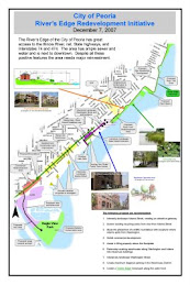
The biggest natural amenity for Peoria is the beautiful river, lake, wooded bluffs and ravines. But there are few places in the Heart of Peoria to view the lake. This plan would create a beautiful drive overlooking the river and lake for all the people to enjoy.


Q . The islands will wash away

Good engineers can certainly construct an island that will not erode. And good environmentalists can properly design and seed the islands and wetlands to promote biodiversity and improve habitat.

Q. You should not use sediment to create the islands - takes up flood plain.

Any action must be approved by the Corps of Engineers and IDNR and our own excellent Public Works and Planning staff. The tiny islands (7 acres) would be placed in the over 2,500 acre lower lake, creating a minimal impact. But if this is a concern, material from the estuary across the river could be used. This material is already above the normal water level, so moving it across the river would have no impact.

Q. No one will build nice homes next to a railroad track and public housing.

If you are correct, the development will not happen.

Q. No one wants to live in the old part of the City anymore. Too much crime and deterioration.

If all developers agree with you, then you have nothing to fear - the development will not happen.

Q. This is a pipe dream, and will never happen. The City is always changing its plans.

I hope you are incorrect. Time will tell. In any event, it will take a very long time to develop the entire Green edge. But if it is developed, Peoria will have a great River park running all the way from War Memorial Drive south to downtown, with a beautiful scenic drive connecting downtown to Grand View Drive.

Q. What happens next?

We will present the proposal to the Planning Commission at 1:30 pm on Wed Feb 20, 2008 at City Hall on the floor. You are welcome to attend and voice your concerns. It then proceeds to the City Council. If they turn it down, then we drop it and move on to other efforts. If they approve it, we would issue an RFP (Request for Proposal), and look for a quality developer. We would ask the Corps to design and construct the islands.

Please send any more questions or comments to Craighullinger@gmail.com, and I will respond. Thank you for your consideration.

Tuesday, February 12, 2008

Proposed Islands


Lakeshore.jpg
159K

View Download


Islands.jpg
74K View Download


Email and drawings from our Environmental Engineering Consultant on the proposed islands developed and refined as a result of our meetings with environmental and neighborhood groups.


Attached are the islands perspective that Paul and I put together for you. In the drawing, you will find an overview of the two islands with an enhanced existing shoreline; a vignette of a close-up view of the area between the two islands; and finally a colored plan view of the island component of the project.


I know you would like to swap the wildlife island and the recreation island. But after consulting with our landscape architect, we feel that the original concept should stay for both practical and various design reasons. Placement of the access ramp is best at the current proposed location. There may not be enough room to do so at the lower island because the bluff narrows down in that area.


Also, we'd like to place the overlook tower to be aligned with Norton Street. Streets leading to the lower island are blocked by the PMP buildings. In addition, there needs to be a short separation between the Riverplex and the recreation island from a design standpoint. It is only a short walk between the two focal points; plus people will be able to enjoy the view of the river scenery and wildlife on their way to the recreation island.


Let me know if you need any changes to the drawing.


Jack T.P. Chan, Ph.D., P.E. Water Resources Engineer LAND RESOURCE MANAGEMENT GROUP 525 East North Street, Suite F Bradley, IL 60915 Email: jchan@lrmg.net Phone: 815.928.8990 x228 Fax: 815.928.8606